|
|
||||||

|
||||||
|
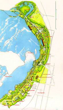
Since 1885 Canada's Niagara Falls and Niagara River corridor have been under the jurisdiction of The Niagara Parks Commission. Its lands stretch 56 kilometers from Lake Erie to Lake Ontario, recording 600 million years of geological history and 12,000 years of human settlement. In 1987 The Niagara Parks Commission realized it needed to develop the potential of the region without compromising the natural beauty that had made Niagara famous - a challenge that it presented to Moriyama & Teshima. For many visitors to Niagara Falls, traffic and parking had become a major deterrent. The master plan recommends an integrated transportation system that diverts heavy traffic from the Falls. This is now being implemented by the City of Niagara Falls. Guided by Moriyama & Teshima's master plan, The Niagara Parks Commission has been upgrading visitor facilities, developing new attractions, improving transportation and pedestrian movement, as well as protecting significant cultural and natural sites . The Niagara Parks Commission's lands couldn't be considered in isolation from the public and private lands along its periphery. The continuing economic health of the region as a whole depends on the awareness, priorities and activities of all the region's stakeholders. Therefore, the Master Plan was developed in consultation with three local municipalities, a regional municipality, Ontario ministries, historians, business owners, tourism operators, landowners, local residents, and the New York State Office of Parks. Awards:
|
|||||

|
||||||